Environmental Assessment Procedures
With the Environmental Assessment Code (EAC –> please click here for download) adopted 1 June, 2017 the old environmental impact permit system was abolished. Instead of a permit, an environmental decision will be issued based on an Environmental Impact Assessment (EIA) and the mandatory procedure beforehand. This procedure consists of three main steps:
- Scoping: to determine the list of information to be obtained and studied for an ESIA which are concluded in a Scoping Report;
- Environmental Impact Assessment of the project resulting in EIA report;
- Review of assessment results, upon which the justified conclusion and Environmental Decision is issued
Public participation results – an integral part of the Scoping Report
The new approach of stakeholder engagement and public involvement (‘Inform – Invite – Involve’) has as scope to gain insights and understanding on social, historical, cultural, and socio-economic factors related to the construction of a new landfill. These factors are considered equally important as the technical, economical, logistical, and environmental factors for the site selection process.
An equally important scope is to identify during discussions (Focus Group Meetings) and public meetings the development needs and priorities of the communities adjoining the potential site locations. These needs and possible resulting community development measures are important aspects that will be considered and discussed during the meeting(s) of the Site Advisory Committee (SAC) and which can play an important role for the final decision.
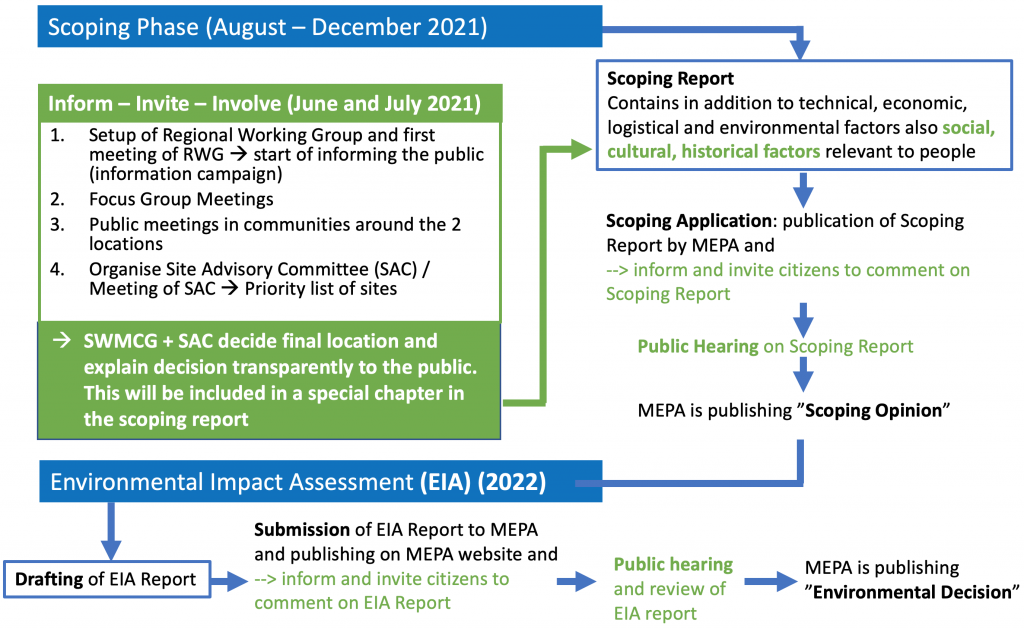
The actions carried out to assure intense stakeholder engagement and public involvement (‘Inform – Invite – Involve’) become an integral part of the process of drafting the scoping report. The setup of the Regional Working Group (RWG), carrying out Focus Group Meetings in the villages adjoining to potential site locations, the organisation of the public hearings, and the establishment of the Site Advisory Committee (SAC) for ranking the sites go inline and complementary to the drafting of the Scoping Report.
The documentation of the public meetings and the explanation and justification for the final location of the landfill by the SAC will be integrated as a dedicated chapter into the scoping report.
The figure below illustrates how the new approach will be integrated seamlessly into the existing procedure as defined by the Environmental Assessment Code (EAC).
What is Scoping?
According to the Environmental Assessment Code (EAC) for Georgia, Scoping is the first of several steps that need to be done in order to receive a construction permit for the construction of a new landfill. The first step of the scoping process is, to draft a scoping report. In the scoping report, the following subjects are covered:
- Define the environmental and social legal framework and standards that the project should comply with
- Identify project alternatives to be evaluated in the EIA
- Establish environmental and social baseline conditions at the project’s site and gaps in information that needs to be fulfilled during the EIA
- Identify early in the design process whether there are any major environmental and social issues at the proposed site that could become obstacles to the project’s implementation
- Ensure an early identification of possible impacts and mitigation measures to be considered in the project design to avoid, reduce or compensate for negative impacts and enhance positive impacts
- Establish methodologies for impact assessment and the scope of work for the EIA
A very important scope of the scoping report is, to provide an early opportunity for public discussion and engagement with stakeholders and consider their opinion in the project.
What are Focus Group Meetings?
Before organising public meetings, there will be carried out in the villages adjoining the potential site locations ‘Focus Group Meetings’. Each focus group meeting will be constituted by 8-10 representatives of the local community representing each target group of their village:
- Initiative groups/cooperatives
- Citizens/ opinion makers / elderly people
- Members of the pasture user households near the landfill
- Business sector/ private sector/greenhouse owners
- Young population
- School teachers / Professional education centers/
Where possible, separate meetings will be held with men groups and with women groups. During the meeting, a big detailed map of the potential site location will be used in order to collect and to put written information in form of stickers on the map. This will result in detailed specific information about physical infrastructure (water, sanitation, electricity, fuel, communication, health and education facilities and services, markets, business, and commercial sites), about land-use patterns (cropping, pasture, forest, special areas, cultural sites), natural resources (including seasonal food collection from forest areas/fishing) and about socially and culturally important places ( historical sites, sites of celebration, burial sites, religious sites/places of worship, specific meeting places).
This map with all information will then serve as a guide for discussion with the scope to find out more information about the needs and priorities of the community referring to community development measures.


